Balaclava Mill Run
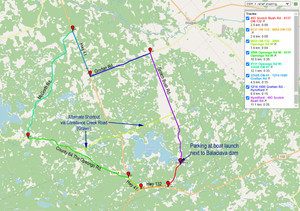
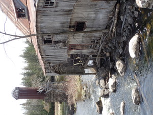
This is a beautiful 51 km ride through farm land and wooded countryside. You begin at the abandoned mill in Balaclava with parking at the boat ramp across the road. Please be careful to not block the ramp or to park in such a way as to prevent people with boat trailers from parking. The old mill is dangerous and private property. STAY OUT but take all the pictures you like.
Timing for the ride is between 2 ½ and 3 hours with 255 metres of climbs overall.
It is suitable for all style bikes with paved roads on the entire route unless you decide to take the shortcut.
Download a GPX navigation file here: http://www.ovcata.ca/userfiles/file/Balavlava%20Mill%20Run%20GPX.gpx
DIRECTIONS:
From the parking area TURN RIGHT onto Scotch Bush Rd. and continue to the junction with Hwy 132 in Dacre. Note the beautiful old church on your left as you come into Dacre.
TURN RIGHT onto Hwy. 132 and proceed to junction with Hwy. 41. TURN RIGHT onto Hwy. 41.
You will ride a short distance on Hwy. 41 to the junction with the historic Opeongo Rd. TURN LEFT onto The Opeongo Rd. (County 64). Along the way look for signs of the original Opeongo settlement road that will appear and disappear into the foliage.
About 5 ½ kms along the Opeongo Rd. you will see the gravel Constance Creek Road on your right. This is a shortcut that will take you back, crossing Hwy 41 and continuing to Scotch Bush Rd. where you can turn right and ride back to the parking area.
Continue on the Opeongo Rd. to the junction with McGrath across from now closed Breen’s Store. TURN RIGHT onto McGrath Rd. and enjoy your ride through rolling hills, farm and wooded lands.
At the junction with Hwy 41 TURN RIGHT and ride on Hwy 41 to the intersection with Grattan Rd. (County 22). TURN LEFT onto Grattan Rd towards Hynford.
At the Hynford intersection TURN RIGHT onto Scotch Bush Road for the last leg of your ride back to the parking area at Balaclava.


